Here, we outline how to use and interpret individual species accounts. In the following sections, we use bold to simplify locating defined terms used in species accounts.
Sources of Data
Since the discussion on this topic in Sharpe et al (2001), sources of data have changed to a large extent. The Birds of Nebraska — Online is based on Sharpe et al (2001) but has been updated primarily from Seasonal Reports compiled and published in the Nebraska Bird Review. The Seasonal Reports are based on information gleaned from two main sources, eBird and NEBIRDS. Approximately 95% of cited reports are now from eBird and the remainder are from reports submitted to NEBIRDS and are mostly of those by observers who do not use eBird. The few additional reports (at most 1%) come from sightings sent to Nebraska Game and Parks Commission, posts to Facebook birding pages, and injured raptors handled by Raptor Recovery.
Where appropriate, we routinely incorporate Breeding Bird Survey (BBS), Christmas Bird Count (CBC), and Bird Banding Laboratory data and analysis; the specific published sources are cited in the species accounts. Data used in the section “Breeding Phenology” is derived from Mollhoff (2016, 2022), the Nesting Season Reports in Nebraska Bird Review by Esther Bennett 1966-1990, Nebraska Nesting Reports by Wayne Mollhoff 2001-2008, Cornell Nest Cards, and information published in North American Birds 1966-1997, and Nebraska Bird Review seasonal field reports from 1992 to the present. An increasingly useful source for breeding phenology data is the inclusion of breeding data in eBird checklists; the data are based on breeding status codes as outlined in eBird’s Breeding and Behavior Codes : Help Center.
Treatment of Data
Seasonal Terms
As part of the “Status” summary in each species account, we use several terms which are defined here. It is important to note that these terms are not defined by calendar months, but vary temporally species by species. “Spring” and “Fall” are the periods in which individuals of a species are moving from winter range to summer range and the corresponding return movement to winter range; the term “migrant” applies to species engaged in such movements. “Summer” is the period when sexually active individuals in a population engage in reproduction; these populations are defined as “breeders”. Often, birds occurring in summer are not part of a breeding population but may be stalled migrants (usually immature non-breeders) or dispersers into the state; these are referred to as “visitors”. “Resident” is the term applied to species that are sedentary and do not migrate; individuals occupy the same general area year-round. “Winter” refers to the period between fall and spring migration for migrants, or when “residents” are not sexually active.
Arrival and Departure Dates of Migrants
Arrival and departure dates were determined by examination of all available dates for migration period occurrence obtained from sources described above (Sources of Data). Reliable arrival and departure dates were chosen by listing the dates in chronological order and searching for an initial or final cluster of three dates which preferably did not extend over more than 3-5 days. In some cases, we present arrival or departure dates for different regions of the state if significant differences exist. Undocumented dates which fall outside these clusters are generally discarded, although we list some as earlier or later dates (outside the cluster) if they appear reasonable to us. All dates that are accompanied by tangible evidence are included and cited.
Peak Migration Periods
These are noted when there is a cluster of high counts over a relatively short time period; these high numbers are listed for most seasons in each species account as “High Counts”. They are derived from a variety of sources, some anecdotal and may include precise counts and others may be estimates or guesses of actual numbers present. High counts have limited value and may not be comparable between or even within species. Nonetheless, high counts capture notable congregations or numbers and are often representative of peak migration periods when compared to other sources of information.
Citation of Records
We do not provide citations for records derived from Nebraska Bird Review spring and fall occurrence reports, the subsequent (since 1992) Seasonal Reports, or records available in eBird, unless important information is included by the Editor rather than a simple date. Readers can locate the appropriate issue of the Nebraska Bird Review by using the year of the sighting or the appropriate species map in eBird (www.eBird.org, under “explore data”) to obtain an observer’s name. We do, however, provide a literature citation for all records that are part of a published paper, including, but not limited to, articles, including NOU Records Committee reports, in the Nebraska Bird Review and other journals, and regional reports in North American Birds and that journal’s previous titles, American Birds and Audubon Field Notes. Most of the North American Birds citations are attributed to Frances Williams or Joseph Grzybowski in the period 1966-1997 when several observers were not reporting to Nebraska Bird Review. Since 1997, however, almost all observers reported to Nebraska Bird Review, eBird, or NEBIRDS, and from 2003-2023 all Nebraska reports were passed through Seasonal Reports in Nebraska Bird Review to the Southern Great Plains Region section in North American Birds.
Molt
Molt has become much more familiar to birders and ornithologists in the last few years. Pyle’s (1997, 2008) pioneering references have been followed by Howell’s (2010) impressive treatise on molt in North American birds. Stage of molt is now recognized as an important, if not critical, consideration in difficult identification problems. Herein, we follow the terminology used by Howell (2010), which is largely based on Humphrey and Parkes (1959, 1963) with modifications. There are useful summaries of the four molt strategies comprising “Humphrey-Parkes” and which of these strategies are used by the various families of North American birds in Howell (2010, pp. 26-31). In certain species accounts, we include a section on molts to clarify plumages reported and/or expected in Nebraska. Note that, following Howell (2010), we do not use the term “definitive”. We do use the terms “adult” and “immature”; “immature” refers to any individual in a non-adult plumage. “Juvenile” is a specific term within “immature” that refers to an individual in its first post-fledging plumage. We also use the terms “first cycle”, “second cycle”, etc.; “first cycle” includes all molts prior to achieving second basic, and, depending on the species, may involve one, two, or three molts. From second basic on, there are one or two molts per cycle, two if the species has an alternate plumage (Howell 2010).
Style Conventions
Geographic
Throughout, we have used the terms “north”, “south”, “east”, and “west”, which refer to regions of the state (Fig. 8). We have also on occasion used the terms “southwest,” “southeast,” “northwest,” and “northeast”; these are self-explanatory and comprise parts of the four major sections of the state. The term “central” combines “north” and “south.” “Central” is often divided into “west central” and “east central”. West central includes Cherry County and the 15 counties directly south of Cherry County, while east central includes the 33 counties within the central that are east of the west central.
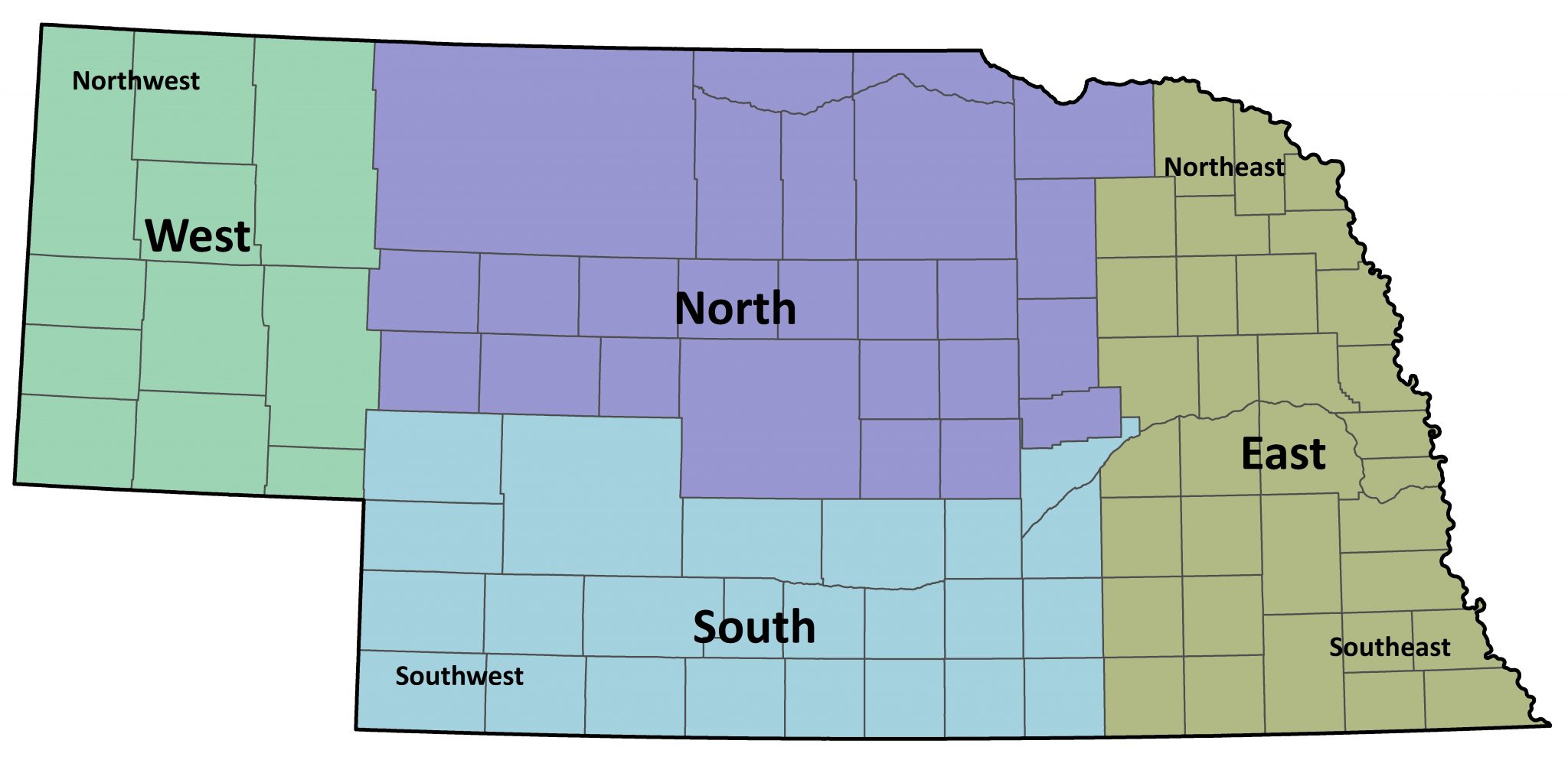
Figure 8. Geographic regions of Nebraska used in species accounts.
There are also several landscapes or landforms within the state that overlap county boundaries and are referred to in individual species accounts because they influence the occurrence and distribution of birds in the state. Below, we identify these landscapes or landforms features and provide a brief description of their physical environment and ecology.
Escarpments
There are a handful of rocky areas with high topographic relief that rise sharply above the surrounding landscape in the Nebraska Panhandle (Figure 9). The Pine Ridge is the largest and most prominent. It rises 250 to 300 meters (800-1,000 feet) above the plains to the north and was formed by erosion by the White River and its tributaries (Condra 1906). The escarpment is dominated by ponderosa pine woodlands (Pinus ponderosa), although riparian areas along the many streams found at the bottom of canyons and draws have extensive deciduous shrubs and trees (Schneider et al 2011). The Wildcat Hills lie between the North Platte River and Pumpkin Creek valleys and rise over 350 meters (1,150 feet) above the former and over 200 meters (656 feet) above the latter (Condra 1906). Like the Pine Ridge, the Wildcat Hills possess extensive areas of ponderosa pine, but bottoms of canyons also support stands of deciduous trees and shrubs. To the south of Pumpkin Creek is a landform we refer to as the Bighorn Escarpment. This name, or any other, is not widely-accepted and others have used names such as the southern Wildcat Hills (Schneider et al 2011) or suggested it be referred to as the Cheyenne Escarpment, the latter is in reference to the Cheyenne Plains identified in Stout et al (1971) that lies immediately to the south. We chose the Bighorn Escarpment because the landform “Bighorn Mountain” is part of this escarpment and also because this feature is distinct and isolated from the Wildcat Hills; there are important differences in birdlife between the Wildcat Hills and Bighorn Escarpment. The Bighorn Escarpment has extensive areas of ponderosa pine, but lacks perennial streams and extensive areas of deciduous trees and shrubs such as those found in the Wildcat Hills and Pine Ridge. The Pine Bluffs and Sidney Draw Escarpment are two relatively minor features associated with the Lodgepole Creek drainage. The Sidney Draw Escarpment includes vertical cliffs which lack extensive areas of ponderosa pine. The Pine Bluffs barely extends into Nebraska from Wyoming and the minor canyons are the only area in the state where limber pine (Pinus flexilis) is found. Other areas of escarpments associated with and identifiable by major rivers are also found in the state (e.g., along the North Platte River Valley in Garden and Keith Counties).
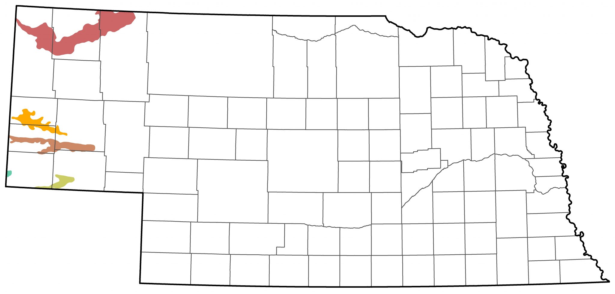
 Figure 9. The location and extent of major escarpments in Nebraska.
The Sandhills and sandsage prairie
The Nebraska Sandhills covers approximately 30,000 square kilometers (19,300 square miles) in north-central Nebraska (Schneider et al 2011). The landscape is the largest stabilized dune system in the Western Hemisphere and one of the largest intact tracts of grassland remaining in North America (Schneider et al 2011). The dunes, ridges and valleys of the Sandhills are comprised of fine-grain windblown sand that is generally not more than 30 meters (100 feet) in depth (Condra 1906). The region sits upon areas of extensive groundwater from the High Plains Aquifer. Lakes and wetlands are abundant and are formed where groundwater permeates above the soil profile in depressions (LaGrange 2005). Notable areas of lakes and wetlands are found in northern and western areas of the Sandhills. Areas of Sandsage Prairie exist in southwestern Nebraska, which is similar to the prairie found in the Sandhills, except that the shrubby plant sandsage (Artemisia filifolia) is common, as the name implies. Other small, isolated areas of sandhills (note un-capitalized “s”) found in the south and east are notable because they usually have not been fully converted to row-crop agriculture and thus are now often isolated patches of grassland in otherwise intensely farmed landscapes.
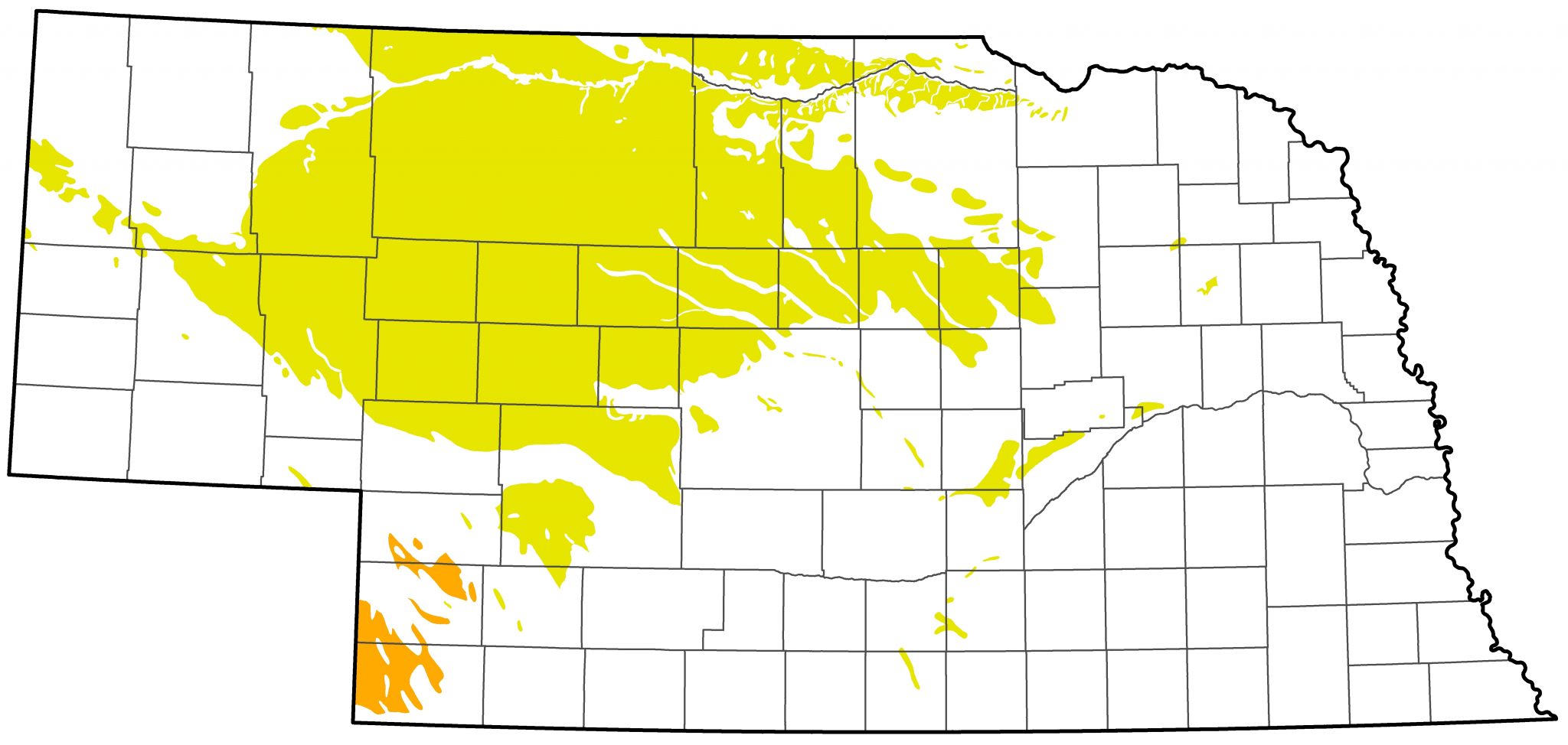 Figure 10. Location and extent of the Nebraska Sandhills in north-central Nebraska and other minor and spatially-isolated dune fields (yellow). Sandsage prairie (orange) occurs in southwestern Nebraska.
Plains and Playa Landscapes
Several relatively flat landscapes (plains) with embedded playa wetlands encompass extensive areas of Nebraska. Playas are wetlands located at the lowest portion of a closed watershed which intermittently hold run-off from precipitation (see Smith 2003). These landscapes have always been important in influencing bird distribution and occurrence because they lack well developed drainages and do not possess riparian corridors. The relatively level land and fertile soils of these plains has resulted in their conversion to row-crop agriculture since settlement by European Americans. Many of the small wetlands have been completely eliminated by drainage and/or land levelling, numerous others have been altered by farming, and large ones are generally degraded due to culturally-accelerated sedimentation and invasive plant species (LaGrange et al. 2011). Remaining functioning wetlands are often isolated in extensive agricultural landscapes. The best-known of the landscapes is the Rainwater Basin (RWB) which totals approximately 10,000 square kilometers (~4,000 square miles) south of the Platte River in south-central Nebraska. Historically, the RWB landscape was defined by prairie grasslands interspersed with ephemeral playa wetlands, which numbered in the thousands (LaGrange 2005). Most of these were small (e.g., < 1 hectare [2.47 acres]), but others were much larger and totaled more than 100 hectares (247 acres). The primary water source for the playa wetlands is run-off. Therefore, water levels of these wetlands vary annually in depth, expanse, and seasonality due to variable precipitation regimes in the Great Plains. The Central Table Playa Region is found north of the Platte River in isolated tablelands surrounded by areas dissected by drainages (LaGrange 2005). The Southwest Playa Region is found throughout a large area of the southern Panhandle and southwestern Nebraska. The Southwest Playas tend to be smaller than playas found in the Rainwater Basin and since precipitation averages less in western areas compared to eastern areas, these wetlands tend to hold water less frequently and for shorter periods (LaGrange 2005). The Todd Valley includes a number of small discreet areas located in an ancient valley of what is now known as the Platte River (LaGrange 2005, Jorgensen and Brenner 2019). Other minor playa regions, such as a relatively small area in Boyd County, as well as unmapped areas in Box Butte and Sheridan Counties are also found in Nebraska.
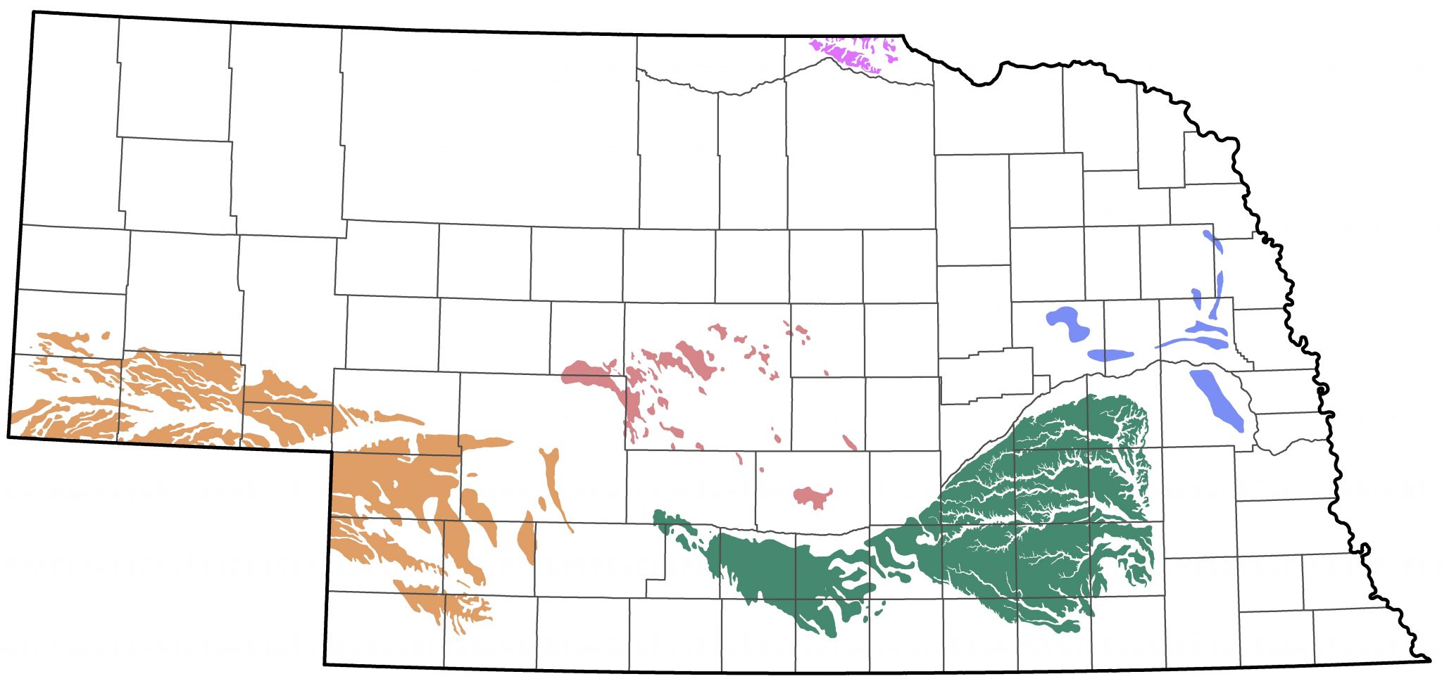
 Figure 11. Location and extent of plains and playa regions in Nebraska. Small isolated playa areas of these regions occur outside of those areas which are shown on the map.
Literary
In general, we utilize standard scientific writing style (Hopkins 1999) with a few noteworthy deviations. We capitalize all proper nouns, such as “Platte River Valley”, “Calamus Reservoir”, and Bushnell Cemetery”. In all instances, we abbreviate “County (Counties)” to “Co (Cos)”. In citations within the species account text that involve multiple authors, we omit the period after “et al”.
Arrangement of Species Accounts
Each account consists of several sections that are described below.
Species Name
We generally follow the names used by the American Ornithological Society in its checklist, which is updated annually via its Supplements. See discussion under “Taxonomy” below.
Status
The term “status” describes the numerical, temporal, and spatial characteristics of the occurrence of a species within a defined area, in this case the state of Nebraska, using defined sets of descriptors.
With very few exceptions, which we note and for which we provide countering evidence, we follow the decisions of the Nebraska Ornithologists’ Union Records Committee’s (NOURC) Official List of the Birds of Nebraska. The terms “accepted” and “non-accepted” records refer to our decisions; many of these records were not submitted or required to be submitted to the NOURC. Species whose occurrence in Nebraska is not convincingly documented are characterized as having “No accepted records” and their names are bracketed (e.g., [Swan Goose]) in their species accounts.
Abundance descriptors are intended to provide a guide to the numerical occurrence of a species for each season. Traditionally, such descriptors were formulated around the likelihood a competent observer will find the species and in what numbers, but the advent of eBird (eBird.org) and its near-universal use by active observers has created a large database of records that can be used to revise the abundance descriptors used in Birds of Nebraska- Online (BONO). Our experience shows that currently around 95% of records used in BONO are found in eBird; the remaining 5% are from sources such as Facebook bird groups, the NEBIRDS email group, and personal communications to us. The following definitions for descriptors should be viewed as guidelines rather than exact cut-off points.
We use the following descriptors: “abundant”, “common”, “fairly common”, “uncommon”, and “rare”. These descriptors are intended to provide a coarse measure of relative abundance of a given species through the lens of an individual observer in appropriate habitat and season and assume ability to detect and identify the species. Field trips are excursions where an observer spends sufficient time and effort to detect the overwhelming majority of species present in an area. Abundance descriptors may only apply to species for short windows during an entire season; descriptors therefore usually reflect the abundance around peak migration, summering, or wintering numbers. For example, a “common spring migrant” may only be common during a brief window in mid-May. Other species, such as nightjars or owls, may require special effort to detect.
Abundance descriptors are based on decades of records and observations, most notably eBird in recent years, and represent expected occurrence patterns. It is not unusual for a species to occur at higher or lower abundance than expected, but updates in status are generally only made when longer term changes can be statistically documented.
Species that are expected on any field trip by an experienced observer in appropriate habitat and season are “abundant”, “common”, or “fairly common”; “abundant” refers to occurrence at times in flocks or aggregations, “common” when usually not in flocks but when the species may be expected and occurs at a density where numerous individuals will be detected during a field trip, and “fairly common” when a species occurs at lower densities where a few individuals are expected to be detected during a field trip. Species not regularly or routinely expected on every field trip in a season and in appropriate habitats but are expected to be found once or a few times during season by an observer, are “uncommon”; “rare” applies when a species is collectively reported fewer than five times in a season. Occasionally, we add the modifier “local”, which indicates that in specific areas or localities within the range, a species may be more numerous than it is throughout the rest of its range.
Species carrying the descriptors “abundant” through “rare” are considered “regular” or “casual” in Temporal occurrence; “regular” species are those occurring in at least eight years in the most recent 10, whereas species occurring 2-7 years in the past ten are described as “casual”, or, alternatively, “less-than-annual”. Species occurring 8 years in the past 10 may be considered “regular” or “casual” at our discretion. Those that have occurred only once in Nebraska are described as “accidental”. Also considered temporal descriptors are “extirpated”, a species that has occurred but is no longer found in Nebraska although it still occurs elsewhere, and “extinct”, a species that no longer occurs anywhere.
Also considered temporal descriptors are the seasonal terms “spring”, “summer”, “fall”, and “winter”; these are defined above and are generally combined with a descriptive noun for the species such as “breeder”, “migrant”, “visitor”, or “resident”, also defined above (see Seasonal Terms). Thus, a species may possess the status “spring migrant”, or “winter visitor”. Species defined as “accidental” are accompanied by a seasonal descriptor referring to the season in which the single occurrence took place, such as “Accidental in Fall”.
The final set of descriptors used in defining “status” are spatial; these include the geographic terms discussed above (see Geographic Conventions) along with the term “statewide” and indicate where in the state the species occurs in a given season. Thus, a species may be a “Common spring migrant east”, “Rare winter visitor north”, or “Uncommon resident statewide”.
Range Maps
For most regular-occurring species we include a map that shows the spatial distribution of a species occurrence in the state. Sharpe et al. (2001) did not include range maps in species accounts. Maps provide a generalized illustration of a species’ range and should be used in conjunction with the text found in species accounts. However, we purposefully created maps that show a relatively high degree of detail based on the best available information even though in some instances range limits for some species are not well defined because of limited data. We believe this approach creates an opportunity to show where current maps can be improved as observers make additional sightings. For an example map with a legend showing the style convention used for the range maps see Fig. 12.
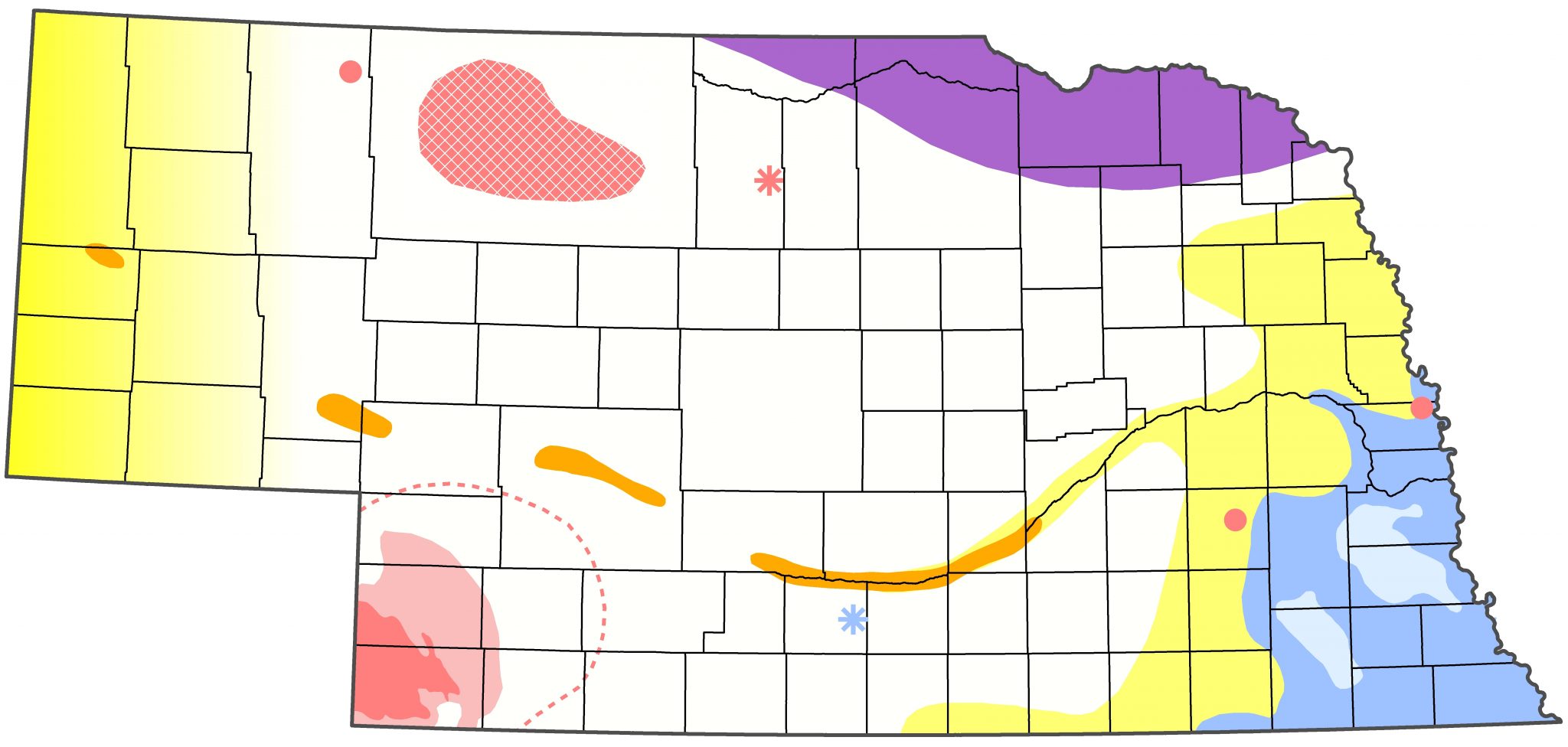

Figure 12. Example of a range map used in species accounts.
Documentation
This section cites, to the best of our knowledge, the first tangible evidence for occurrence of each species in the state. In most cases a specimen is available, usually held in a major museum collection, but for many recent additions to the state list, a photograph or sound recordings are used. In a few cases, written descriptions remain the best evidence available.
Taxonomy
This section attempts to provide taxonomic context for each species treated herein, including whether the species is monotypic or whether there are additional subspecies and where they occur.
There are several sources for taxonomic status of species and subspecies, often with conflicting opinions, which sometimes requires a decision as to which to follow in a project like Birds of Nebraska- Online. However, recent discussions under the auspices of the Working Group on Avian Checklists (WGAC: International Ornithologists’s Union, October 2022) are in the process of reconciliation of checklists produced by major taxonomic publishers such as IOC (IOC World Bird List), AOS (American Ornithologists’ Society), Clements, and about 26 others. As of this writing (September 2025) this task was completed and the first version was published as AviList (2025). Herein, we follow taxonomic decisions in AviList.
Avibase uses a taxonomic philosophy (Lepage et al 2014) which summarizes previous varying taxonomic opinions into entities referred to as “taxonomic concepts”, which avoid specific mention of species and/or subspecies, although these are enumerated under the appropriate taxonomic concept. These concepts bear some resemblance to the system of “groups” used by eBird in its taxonomy; eBird is gradually incorporating the WGAC decisions.
Resident, Spring, Summer, Fall, Winter
Pertinent information is included under the appropriate seasonal descriptor, including early and late dates for migration periods in spring and fall, “Breeding Phenology” (below) for species that breed in Nebraska, and “High Counts” for seasons where such data is available. For species of “accidental”, “extirpated”, or “extinct” occurrence, a single category entitled “Record(s)” is used instead of the seasonal descriptors following “Documentation” and “Taxonomy”, and for species with “No accepted records”, “Comments” is the only category used following “Documentation” and “Taxonomy”. For species whose status in all seasons is other than “regular”, except for “No accepted records” species, we list all records in columnar form. Otherwise, records are provided in text form.
Regarding “Breeding Phenology”, the dates presented are from a variety of sources (listed above under Sources of Data) and include most if not all of those that have been published. For many species, there are few dates available and those which are available were collected opportunistically. For some species, this creates apparent anomalies in the phenological sequence. Correct treatment of this data would include sample size (“N”) and Standard Deviation measures. The best solution, however, is to collect more data. For more complete phenological information, covering a species’ entire breeding range, the reader is referred to “Birds of North America Online” (birdsna.org).
Comments
This section is added to some species accounts to provide important information pertinent to a given species that does not fit well into any of the above categories. It is also used instead of seasonal descriptors for species of “No accepted records” occurrence.
Images
This section includes an image or images of or associated with each species. All images were taken in Nebraska. Images are arranged in galleries and each image is a thumbnail that can be clicked on for a larger view. Image galleries generally include the header image that is shown in the background at the top of each species account. Images were contributed by a number of individuals. If you have an interested in submitted your photographs of Nebraska birds for possible use on the Birds of Nebraska – Online, please do not hesitate contacting us.
Abbreviations, Literature Cited, Recommended Citation, Acknowledgements, Appendix
These self-explanatory sections are included as required. “Abbreviations”, “Literature Cited” and “Recommended Citation” are included in almost all Species Accounts, “Acknowledgements” is included if deemed necessary, and “Appendix” is a repository for additional information such as graphics or tables that might be deemed necessary to fully explain certain statements in the Species Account proper. Throughout “Literature Cited”, we abbreviate “Nebraska Bird Review” to read “NBR”; all NBR articles cited are available at University of Nebraska’s Digital Commons. When referring to Breeding Bird Survey trend estimates we parenthetically include “95% C.I.”, which stands for credibility interval. The 95% credibility interval represents the “2.5% and 97.5% percentiles of the posterior distribution of trend estimates” (USGS 2017).
Literature cited
Condra, G. 1906. Geography of Nebraska. University Publishing Company, Chicago, Illinois, USA.
Hopkins, W.G. 1999. Guidelines on style for scientific writing. Sportscience 3(1).
Howell, S.N.G. 2010. Molt in North American Birds. Houghton Mifflin Harcourt, Boston, Massachusetts, USA.
Humphrey, P.S., and K.C. Parkes. 1959. An approach to the study of molts and plumages. Auk 76: 1-31.
Humphrey, P.S., and K.C. Parkes. 1963. Comments on the study of plumage succession. Auk 80: 496-503.
Jorgensen, J.G., and S.J. Brenner. 2019. Migratory shorebird, waterfowl and waterbird use of wetlands in the Todd Valley, Nebraska. Nongame Bird Program at the Nebraska Game and Parks Commission, Lincoln, Nebraska, USA.
LaGrange, T. 2005. Guide to Nebraska’s wetlands and their conservation needs. Nebraska Game and Parks Commission, Lincoln, Nebraska, USA.
LaGrange, T., R. Stutheit, M. Gilbert, D. Shurtliff, and P.M. Whitehead. 2011. Sedimentation of Nebraska’s playa wetlands: a review of current knowledge and issues. Nebraska Game and Parks Commission, Lincoln, Nebraska, USA.
Lepage, D., G. Vaidya, and R. Guralnick. 2014. Avibase – a database system for managing and organizing taxonomic concepts. Zookeys 420: 117-135. https://doi.org/10.3897/zookeys.420.7089.
Mollhoff, W.J. 2016. The Second Nebraska Breeding Bird Atlas, 2006-2011. Bulletin of the University of Nebraska State Museum Vol. 29. University of Nebraska State Museum, Lincoln, NE.
Mollhoff, W.J. 2022. Nest Records of Nebraska Birds. Nebraska Ornithologists’ Union Occasional Paper Number 9. Zea Books, Lincoln, NE.
Pyle, P. 1997. Identification Guide to North American Birds. Part I, Columbidae to Ploceidae. Slate Creek Press, Bolinas, California, USA.
Pyle, P. 2008. Identification Guide to North American Birds. Part II, Anatidae to Alcidae. Slate Creek Press, Bolinas, California, USA.
Schneider, R., K. Stoner, G. Steinauer, M. Panella, and M. Humpert. 2011. The Nebraska Natural Legacy Project: State Wildlife Action Plan. 2nd ed. Nebraska Game and Parks Commission, Lincoln, Nebraska, USA.
Sharpe, R.S., W.R. Silcock, and J.G. Jorgensen. 2001. The Birds of Nebraska: Their Distribution and Temporal Occurrence. University of Nebraska Press, Lincoln, Nebraska, USA.
Smith, L.M. 2003. Playas of the Great Plains. University of Texas Press, Austin, Texas, USA.
Stout, T.M., H.M. DeGraw, L.G. Tanner, K.O. Stanley, W.J. Wayne, and J.B. Swinehart. 1971. Guidebook to the Late Pliocene and Early Pleistocene of Nebraska. Papers in the Earth and Atmospheric Sciences, 51, accessed 31 Dec 2017.
U.S. Geological Survey. 2017. Trend and Annual Index Information, accessed 31 Dec 2017.
